
The Traffic Accident Reconstruction Origin -Article-

|
The Traffic Accident Reconstruction Origin -Article-
|
|
Aerial Photography: Applications In Accident Reconstruction
by:
Robert Wyman and Ross Cobb
This article approaches aerial photography from two perspectives. Bob Wyman is a consulting accident investigator. He writes about this topic from the perspective of the end user of aerial photographs. Ross Cobb is a pilot and owner of Aerials Inc, an aerial photographic service. He offers the technical explanation.
Introduction (by Bob Wyman)
Pick up almost any magazine and you will find an aerial photograph. Beautiful landscapes, scenic coastlines, incredible views of everything from honeymoon vacation spots to "tough trucks" climbing up mountain ranges. Aerials are used to illustrate advertisements, editorials and feature articles. But, a technical side of aerial photography also exists.
Aerial Photography has many applications for the traffic accident reconstructionist. It is far more than just an attractive exhibit to impress jurors or a client. Properly scaled vertical aerial photography can actually be a crucial part of a successful investigation.
A Typical Scene Scenario
A major investigation usually begins this way. You roll up to the scene to find chaos. You observe physical evidence that will help understand the collision. Meanwhile Fire- Rescue is attending victims, while principals, witnesses and onlookers wander about your scene. As the investigator your most important job is to prioritize your time. On the list are the following tasks: secure the scene, identify involved parties, facilitate EMS access, locate witnesses, and eventually document evidence. Usually, by the time you finally get to the evidence it has been disturbed, swept away, or washed down. Your once-fresh evidence has changed. Your scene is losing its integrity.
Here's an alternate response to this scenario. This time, you think ahead, grabbing a can of orange traffic marking spray paint along with your clipboard. You evaluate the scene and head toward the EMS activity, spray-painting the skid mark end point and outlining the debris pattern on the way. After fulfilling your duties with EMS and the victims, you spray the rest-location of the four tires of that vehicle. On your trip back across the intersection to speak to witnesses, you mark more of the evidence and the final rest position of the other vehicles.
The point, of course, is to put evidence documentation at the beginning of your on-scene task list instead of at the end. In this manner, photos and measurements may be completed later or even during the next day or two without any loss of information. Documenting evidence in paint is the groundwork for calling in air support for an aerial photographic mission.
Vertical Aerial Photographs (by Ross Cobb)
|
Aerial photographs that are the subject of this paper are defined as vertical photos, or those that are taken looking straight down from an aircraft. These photos usually require a special camera mounting apparatus as well as sophisticated aiming and triggering mechanisms. Photos taken out of an airplane window or the door of a helicopter are oblique aerials, and they are taken at such a severe angle to the ground that distortions and perspective effects make the resulting images difficult or impossible to use in a reconstruction environment. Interestingly, even the most carefully held "vertical" or banking shot out of a helicopter is still far less accurate than a controlled vertical using a camera mount designed for this purpose. |
To take and use meaningful vertical aerial photographs, "targets" must be added to the scene. These markings will assist the pilot, aerial photographer and photo lab technician in producing an accurate print. Targets usually consist of "X" designs, squares, triangles or other geometric shapes to help the pilot find the site and establish the photo image boundaries desired. A distance of 100' between targets is useful, especially when the final photo product will be scaled at 1"=10' on the print. In these cases the darkroom technician simply enlarges the image until the targets are 10" apart; the resulting print will be at ten-scale. Placing these targets with a measuring wheel will generally result in accuracy to within a few inches.
Technical Aspects
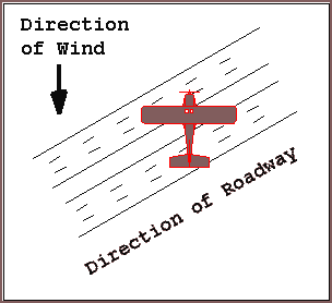
The camera mount, mentioned previously, is an important element in establishing a vertical angle to the ground. It also isolates vibrations and allows the camera to be rotated (in the mount) so that proper site orientation may be accommodated. It is probable that wind conditions will force the aircraft to fly over the site on a specific heading. To keep roadways aligned with the rectangular shape of the photo, the camera must be rotated so the street pattern aligns with the rectangular photo frame. This is more of a cosmetic enhancement than a technical requirement, but a photo enlargement aligned to a roadway grid is easier for most people to view and understand.

Some types of aircraft are particularly well suited for aerial photography. Among one of the best is a Cessna 177. This aircraft has a strutless wing for an unobstructed view from the cabin. It also offers an excellent compromise between low speed flight for vertical aerials and respectable cruise speeds.
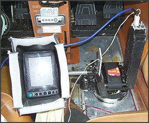
The heart of this or any aerial system is the camera, its mount and monitoring
equipment. Pictured left is one solution to the problem. This photo shows the cameras
mounted in front of the right seat of the aircraft. Note the rudder pedals in
the background. Two cameras are shown in black on the right side of the photo. One
camera is loaded with film and actually takes the vertical. The second camera sends
its video output to the monitor so that the pilot-photographer can be sure of framing
and timing. Slow flying is a relative term. Putting the aircraft in the right place
at the right altitude with the proper heading takes a concentrated effort. Several
of these precision photo-passes are required to be sure critical evidence is not
obscured by traffic.
Film type, camera format, lens, altitude, scene size and final desired product are several of the interrelated variables that must be considered next. An example of how these factors influence the photographic outcome follows.
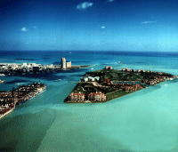
The Results
|
This first photograph is about what one would expect from a ground level scene collision documentation photo. | |
|
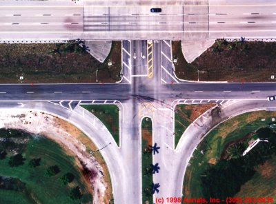
The aerial (reduced in size). | |
|
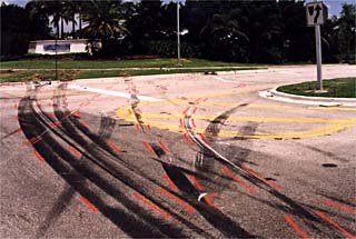
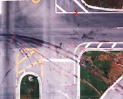
Scene detail. | |

|
It is difficult if not impossible to appreciate the impact and utility of a 30" x 40" aerial photograph. What follows is an attempt to accomplish just that. Taking this link will allow the reader to view a 2 color line representation of the full sized aerial. Downloading this 190 kb gif image takes 4% of the time it would take to load the full color version. |
Using the Aerial for Reconstruction (by Bob Wyman)
The most practical use of a vertical aerial is the ability to measure the scene from the photo. This is possible because the photo has been scaled to known points. With photos enlarged to a usable scale (1"=10' is most often used by reconstructionists) measuring can be accomplished in several ways. At ten-scale, you can easily use your template to measure distances or angles. A second technique is to use a clear overlay on top of the photo. Accident sequence mapping can be easily accomplished by drawing on this overlay. Finally, if CAD is your scene data's ultimate destination, a scaled vertical aerial can be digitized at your drafting table, rather than wandering about in the road.
Beyond all the utility of an aerial, there is its demonstrative value. Add some informative self-adhesive labels, and you've just completed your deposition or courtroom exhibit. To give you an idea of the impact of such a photo, cars will be over one inch long.
Summary
Aerial photos in Accident Reconstruction provide a highly accurate basis for evidence documentation, scene analysis, and reconstruction calculations. They also are demonstrative evidence for courtroom displays, and depositions. Given a bit of forethought aerial photographs can be a viable alternative to standard accident scene practice.
Mr. Wyman is a professional photographer, researcher, technical writer and traffic management specialist. He serves as an independent consultant to reconstructionists, engineers, attorneys, investigators and insurance representatives. His general-interest photographs and articles have appeared in local and national publications, television shows, and exhibits. His forensic photos, accident reconstruction reports and traffic engineering reports have been used at hundreds of local depositions, civil and criminal trials, and land use hearings. He can be reached at [email protected]
|
Copyright ©
|